Historic Typhoon on Course to Strike Japan


Nanmadol, categorized as a “Large and Violent” typhoon by the Japan Meteorological Agency (JMA), and a “Super” typhoon by the Joint Typhoon Warning Center (JTWC) is on course to directly hit mainland Japan.
The monster typhoon dramatically developed from Friday to Saturday with the pressure dropping by 55 hPa in 24 hours. As of Saturday 9pm, Japan time, the central pressure is 910 hPa, making it the strongest tropical system on earth of this year so far.
On Saturday night, JMA issued emergency warnings for winds, waves and storm surge for Kagoshima Prefecture which locates in southern Japan. An emergency warning is the highest level of alert in the nation's warning system.
Record warm ocean
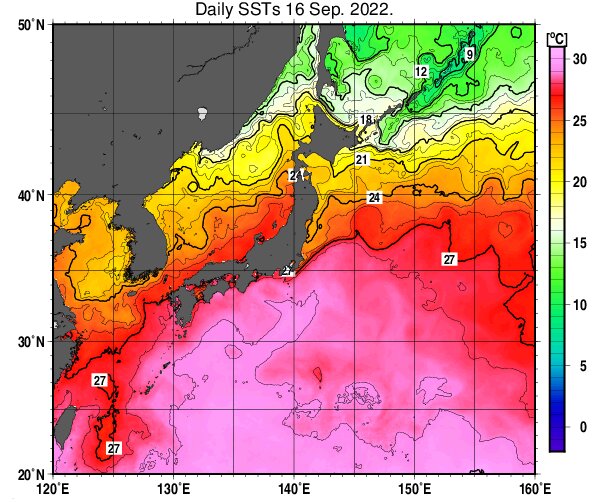
The ocean temperatures surrounding Japan from June to August this year was 0.8 degrees Celsius higher than the 30-year average. That makes 2022 one of the three hottest years along with 2001 and 2016 since records started in 1982. The air temperatures over Japan, meanwhile, were the second highest on record this summer.
May become the strongest on record
The weather agency is predicting that Nanmadol could maintain its intensity and approach or make landfall on Kagoshima Prefecture sometime between Sunday afternoon and evening with a central pressure from 910 hPa to 920 hPa.
Japan has never been hit by a typhoon with the central pressure below 925 hPa. The most powerful storm with the record low pressure upon landfall was Nancy in 1961 (925 hPa) followed by Vera in 1959 (929 hPa). With that said, Nanmadol could become the strongest typhoon ever to hit mainland Japan since reliable records began in 1951.
However, there still is a possibility that the center of the typhoon stays over water without touching the land on Sunday. If Nanmadol misses land, it could slightly weaken before making landfall in northern Kyushu overnight Sunday to Monday.
Expected winds and rain
Nevertheless, the dangerous right side of the typhoon will stay over the island of Kyushu, bringing life-threatening winds, storm surge and torrential rains.
The expected stormy conditions in Kyushu on Sunday are as below:
Rain: Up to 900mm in 48 hours ・・・ Critical risks of floods and landslides
Gusts: Up to 270kph ・・・ As fast as shinkansen bullet trains. Strong enough to destroy houses
Waves: Up to 13m ・・・ Equivalent to a four-story building
Stay on the alert
If you live in an area where the storm is headed, make sure that you stay safe and finish evacuation ahead of the storm’s approach.
Evacuation at night requires extra caution. If you are unable to evacuate, stay on a higher floor in your house and a room furthest from a mountain slope.
Stay informed. JMA is providing information of Nanmadol as well as the risks and conditions of flooding and landslides in your area. NHK WORLD-JAPAN provides 24-hour news in English.