Worst Rain Ever Hitting Western Japan


In contrast to the extreme heat during the Tokyo Olympics, Japan is now experiencing cooler weather and unprecedented heavy rainfall. A three-month worth of rain has fallen in just three days. Authorities are warning that the worst disaster in decades is likely to occur.
(意訳: 東京五輪の酷暑が嘘のように、現在日本を涼しい空気が覆い、過去に例のない大雨が降っています。3日で3か月分の雨が降ったところもあり、気象庁は数十年に一度の甚大な災害が起こる可能性があると警戒を促しています。)
(↑A landslide took place on a slope connecting to Kiyomizu Temple in Kyoto)
How Much Rain Has Fallen So Far?
The worst is occurring in western Japan’s Kyushu island. In the city of Ureshino in Saga Prefecture, an astonishing 925mm (36 inches) of rain fell in 72 hours, making it the all-time record. As its August monthly rainfall is 277mm (32 inches) , the amount that fell in three days is more than three months’ worth. In Unzendake, Nagasaki Prefecture, a record-breaking 840mm of rain was reported in 72 hours. Authorities have issued an emergency warning for heavy rain, the highest level of rain alert in Japan, for Saga, Nagasaki, Fukuoka and Hiroshima Prefectures.
(意訳: 特に大雨が記録されているのが九州で、佐賀県嬉野市では72時間で925ミリの雨が降りました。これは8月の降水量の3倍以上に匹敵します。また長崎県雲仙岳では840ミリと、観測史上最大の降水量を観測しました。大雨特別警報が、佐賀県、長崎県、福岡県、広島県に発令されました。)
What’s Causing The Rain?
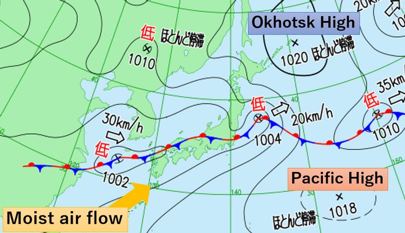
In mid-August, the Pacific high-pressure system typically covers the whole of Japan, bringing oppressively hot and sunny weather. However, the Pacific high has shrunk, and instead another high-pressure system centered over the Okhotsk Sea is intensifying. The two high-pressure systems are pushing into each other, creating a stationary front over Japan. On top of the front, moisture-laden air from the tropics has been flowing into western Japan, resulting in such an enormous amount of rain.
(意訳: 8月中旬は日本全体を太平洋高気圧が覆って、本来なら暑く晴れが続く時期です。ところが現在、太平洋高気圧が南に退き、代わって北のオホーツク海高気圧の勢力が強まっています。この二つの高気圧が押し合い停滞前線を発生させているうえに、高気圧の縁をまわる熱帯の湿った空気が流入し続けています。)
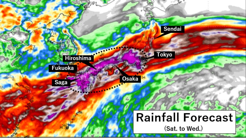
Rain Forecast
How long will the rain continue? The Japan Meteorological Agency is predicting that 300 mm of rain could fall in Kyushu into Sunday morning, an additional 200mm the following 24 hours into Monday morning, and yet more rain at least into next Wednesday. Rain is also spreading to other parts of Japan, threatening to dump flooding rainfall in central and northern Japan into next week.
(意訳: 気象庁は、九州では日曜日の朝にかけて300ミリ、月曜朝にかけての24時間で200ミリ、少なくとも18日頃まで雨が続くと予想しています。大雨は東日本にも広がり、来週まで続く見込みです。)
Useful Links
You can see the risk of landslides/floods for your area from this link.
For those of you who are in the disaster threat zone, please keep up to date on the latest information.
● JMA Website (Radar, rain forecast)
● NHK WORLD JAPAN's special page for heavy rain
(意訳: こちらのリンクから、お住まいの地域の土砂災害や洪水の危険度が分かります。警戒が必要な場所にお住まいの方は新しい情報を入手して、くれぐれも安全にお過ごしください。)