【台風10号】Japan Faces One Of Its Strongest Typhoons


In July, the Western Pacific kept strangely silent. No tropical storms formed over the ocean, making it the first time on record. As storms did not stir the ocean waters, the water temperatures rose, leading to unusual coral bleach near southwestern Japan.
Since August, the ocean suddenly has turned active, producing eight named storms one after another. Two battered the Korean Peninsula with historic intensities, and then the latest typhoon, Haishen, is on course to impact Japan as one of the strongest storms ever for the country.
7月、観測史上初めて台風が一つも発生しなかった。台風が海水をかき混ぜなかったため、海水温が上昇し、サンゴの白化現象が報告されている。しかし8月からは8つの台風が発生し、そのうち2つは韓国に記録的な勢力で上陸した。そして10号が日本にとっての記録的な台風となろうとしている。
Haishen’s Current Conditions
The disturbance got its name Haishen on September 1st, as it intensified to this year’s tenth tropical storm. Haishen means a “god of ocean” in Chinese. As of Friday morning, Japan time, the typhoon is packing sustained winds of 180kph (10min average) with a “very strong” status, which is the second highest on the typhoon scale.
10号は9月1日に発生した。国際名Haishenとは、中国語で海の神を意味する。日本時間4日朝時点で台風の中心風速は50m/sで、上から2番目に強い「非常に強い」勢力である。
Forecast Track
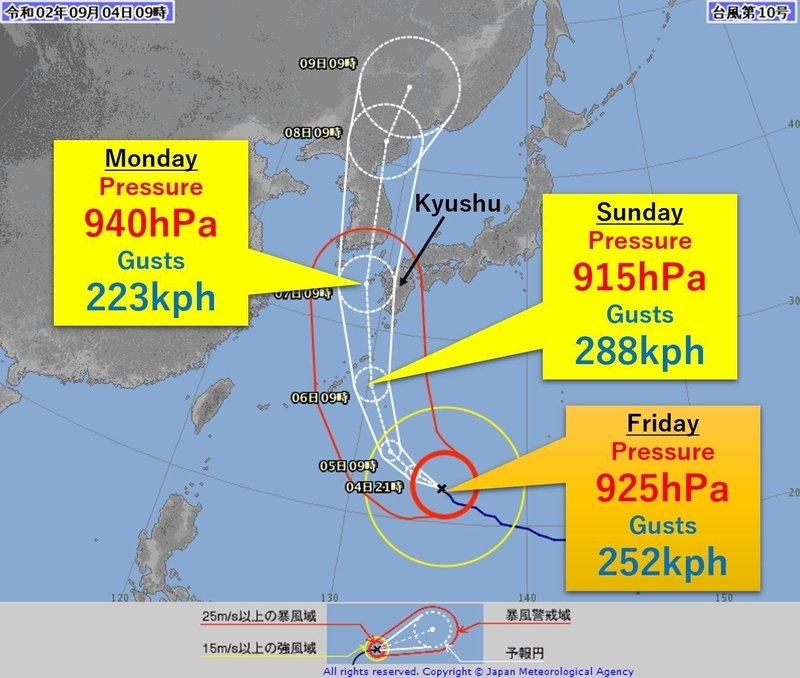
The Japan Meteorological Agency (JMA), which is responsible for the typhoon forecast internationally, predicts that Haishen’s central pressure could drop to 915hPa with sustained winds of 198 kph (10min average) by Saturday. This would categorize Haishen as “violent” status, which is the highest intensity on the afore-mentioned scale. The JMA forecasts it to drift over the southwestern islands into Sunday with the same intensity, getting very close to or even move over Kyushu from Sunday night to Monday morning as a “very strong” typhoon.
気象庁によると、10号は週末までに中心気圧が915hPa、「猛烈な」勢力に発達する恐れがあるという。7日にかけて南西諸島に接近し、7日から8日にかけては九州本土に接近または上陸する恐れがある。
Possible Records in Japan
The southwestern islands including Amami and Okinawa could experience gusts of as high as 306kph on Sunday, which has been experienced only once in the country outside Mt. Fuji. On September 5th in 1966, Typhoon Cora hit Miyako Island, causing gusts of 307kph.
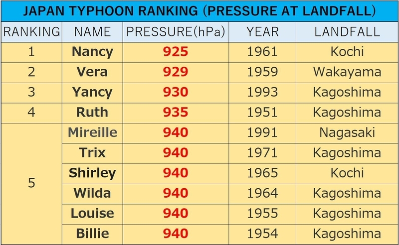
If Haishen makes landfall over Kyushu with a central pressure of 925hPa, Haishen could be remembered as the strongest typhoon to do so since record-keeping began in 1951. The most intense typhoon to hit Japan on record is Nancy, which pummeled Shikoku Island in 1961 with a pressure of 925hPa. Nancy caused extensive damaged, killed 202 people, and injured 5,000 others.
The top ten strongest typhoons for Japan listed below all formed before the year 2000. After 2000, the strongest is Jebi in 2018 with a pressure of 950hPa. Osaka, the third biggest city in Japan, experienced massive damage, and strong winds pushed a tanker into the bridge connecting Kansai International Airport to the mainland, leaving the airport closed for about three weeks.
奄美や沖縄では最大瞬間風速85m/sが観測される可能性がある。これまで国内で85m/s以上の風が観測されたのは、1966年9月5日に宮古島で観測された85.3m/sしかない。
もし九州本土に925hPaの台風が上陸するとなれば、これまでの最強記録である1961年の第二室戸台風と並んで第一位の記録となる。
図は、日本に上陸した10の最強台風(中心気圧比較)を表している。すべてが1900年代である。2000年以降で最強とされているのは2018年の台風19号(950hPa)で、この時関西国際空港と本土を結ぶ橋にタンカーが衝突し、3週間近く空港が閉鎖された。
Possible Records On the Korean Peninsula
Haishen could bring a couple of records for the Korean Peninsula as well. Haishen could approach South Korea into later Monday with a pressure of 940hPa. South Korea has never experienced a pressure below 950hPa since 1904, so Haishen might break the record. Also, with the landfall of Haishen, five named storms would have struck the Korean Peninsula in a year, which has never happened since 1951. The record so far is four storms in 2012 and 2019.
10号は、朝鮮半島でも記録を塗り替える可能性がある。10号は7日午後にかけて、中心気圧940hPaで接近する予想が出ている。韓国ではこれまで950hPa以下の気圧を観測したことはないので、記録が更新される可能性も否定できない。またもし10号が上陸すれば、朝鮮半島に上陸した今年5つ目の台風となる。これまでの最多記録は2012年と2019年の4回である。
Back-to-back Record Typhoons
East Asia has been hit by back-to-back strong typhoons since the beginning of August. On August 26th, Typhoon Bavi made landfall in North Korea with a central pressure of 965hPa. This made Bavi the third typhoon to hit the nation in recorded history. On September 3, Typhoon Maysak struck South Korea. Tongyeong City recorded 952.5hPa, which is the second lowest pressure in recorded history, following the 951.5hPa brought by Typhoon Sarah in 1959.
8月から東アジアは、次々と記録的に強い台風に見舞われている。8月26日には台風8号が北朝鮮に上陸し、1951年以来で3つ目の「強い」勢力での上陸となった。9月3日には9号が上陸し、韓国の観測史上2番目に低い気圧である952.5hPaが観測された。これまでの記録は、1959年の台風に伴う951.5hPaである。
Record Warm Water
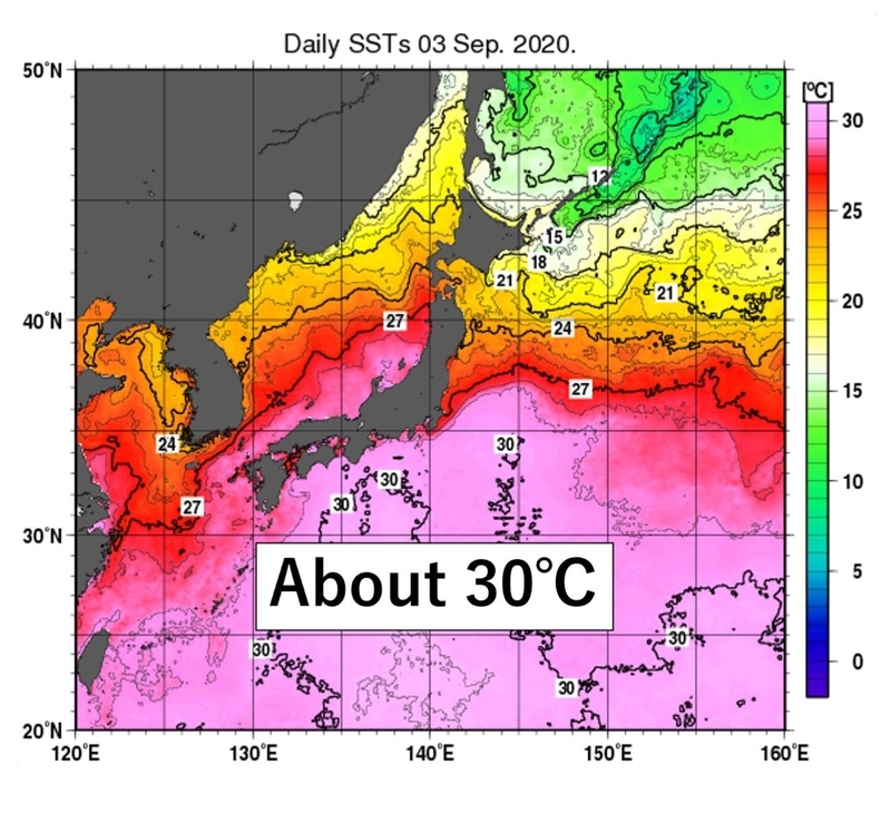
Why are the historic typhoons forming so frequently? Once definite reason is the unprecedented high ocean temperatures. The surface temperatures of the Western Pacific have been about 2 degrees Celsius higher than normal this summer. According to a report released by the JMA last week, an area of ocean south of Japan had an average monthly temperature of 30 degrees Celsius in August, which was the highest recorded temperature in any month of year. This was due to a Pacific high-pressure system that extended further west, blanketing the waters with warm air. Moreover, zero typhoons in July left seawater unstirred and warm. The hot water can supply typhoons with abundance of water vapor, helping to develop the storms.
記録的な台風が連続して発生する理由は、記録的に高い海水温の影響がある。気象庁は先週、日本の南の海上の8月の海水面の平均温度が30℃以上で例年より2℃以上高く、観測史上最高となったと報告している。その背景には、太平洋高気圧が例年よりも西に広がったこと、さらに7月までに台風が発達しなかったことで、海水温が下がらなかったことが関係している。海水温が高いと台風に水蒸気が供給されて、発達しやすくなる。
Prepare For Typhoons
Historically, September brings the strongest and most disastrous typhoons to Japan. With the favorable conditions for typhoon development, we might face challenging conditions. As the dangerous season has just started, we all need to get prepared.
When preparing for the typhoon season, there are some steps you might consider taking, including;
- Plan your evacuation route well ahead of time
- Create a family disaster plan
- Get emergency supplies such as water, food, and medicine
- Due to the fear of the Covid-19, include masks and hand sanitizer
- Get your house ready by cutting weak branches and trees and cleaning drains to avoid flooding
- Have a list of information source for weather such as theJMA, local government, NHK, or install weather apps
統計的に9月は災害をもたらすような危険な台風が発生することが多い。今年は記録的な海の高温で、さらに危険な月になるかもしれない。前もって台風への備えをしておくことが必要である。
**ADDENDUM (9/7)**
Haishen didn’t make landfall in Kyushu, but it approached the island with a central pressure of 945-950 hPa. Haishen caused gusts of 214kph in Nagasaki Prefecture, and 595mm of rain in 48 hours in Miyazaki Prefecture.One woman was found dead in a gutter, four are missing and dozens of people were injured. 470,000 houses lost power at one point.