Record 489mm/24hr Hits Western Japan 【熊本豪雨】


Located in the southwestern part of Japan, and sandwiched by two warm ocean currents, Kyushu is the wettest and warmest area of the country. It holds the national records for the annual and hourly rainfall. (8,670mm, 153mm respectively).
The Southern Kyushu region just notched one of the wettest Junes on record, and they were pounded by even more heavy rainfall on Saturday (7/4). This time it was unprecedented.
Authorities issued an emergency warning for rain in Kumamoto and Kagoshima Prefectures for the first time for these regions. An emergency warning is the country’s highest level of alert and is only issued when life-threatening disasters are happening or imminent.
(日本の南西に位置する九州は、二つの暖流に挟まれ、日本の中でも特に雨が多く暖かい。年間と一時間降水量の国内記録も有する。南部では記録的に雨の多い6月となったが、7月4日に降った雨の量は前例のないものとなった。気象庁は熊本と鹿児島に特別警報を発令した。)
REPORTED RAIN
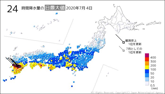
Kumamoto Prefecture, known for an active volcano, was hit the hardest. Though the area is frequently hit by drenching downpours, Saturday’s rain easily surpassed any of the records in the past.
The observed rainfall was as below:
[1 hour]
Amakusa 98mm
[3 hours]
Ashikita 190.5mm
[6 hours]
Ashikita 325.5mm
[24 hours]
Yunomae 489.5mm
Minamata 474.5mm
Amakusa 428mm
(All broke the previous all-time records)
(火山で知られる熊本では、特に大雨が降った。大雨は珍しいことではないが、今回の雨量は前代未聞のものとなった。)
DAMAGE
The rain triggered the Kuma River to overflow. The water led to deadly floods and landslides. Water reached the second-floor of houses, inundated numerous vehicles and destroyed iron bridges. Many people waited for help on top of roofs.
According toKYODO, at least 40 people have been confirmed or presumed dead, including 14 elderly who were in a nursing home when the floodwater hit. 11 others are still missing.
(大雨の影響で球磨川が氾濫し、洪水や土砂崩れが発生、死者が出た。水が家の2階に達したり、車が多数水に浸かったり、複数の橋が流されたりしている。多くの人々が屋根の上で救助を待った。共同通信によると、少なくとも40名が死亡もしくは心肺停止、11名が行方不明となっている。)
CAUSE OF RAIN
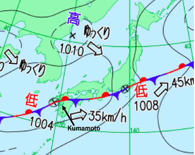
The weather map above is for early Saturday morning when the disaster happened.
The sea surface temperatures around Kyushu are 2-3 degrees Celsius higher than normal, allowing them to bring more rainfall.
The extremely moist air was flowing from the south, magnifying the rainy season front. A particularly developed line of rain, known as "training", formed over Southern Kyushu. Training is a succession of storms which continues to develop and causes rain over the same area for hours.
On July 5, 2017, the training phenomenon caused record rain in Northern Kyushu, killing at least 40 people.
(↑Mechanism of the training phenomenon)
(上の天気図は、大雨が降った4日朝のものである。九州近海の海面温度が2~3℃高く、水蒸気が大量に前線に流れ込んだ。線状降水帯も発生し、九州南部に数時間居座ったため記録的な大雨となった。2017年7月5日に起きた九州北部の豪雨も、この線状降水帯が原因とされている。)
TIMING/GEOGRAPHY ISSUES
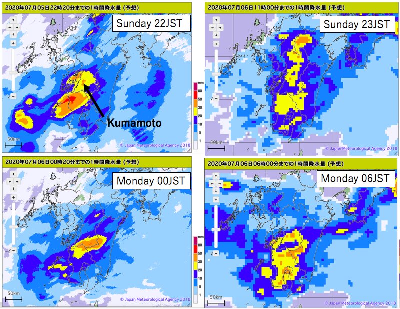
The timing and geography are thought to have made the situation worse.
Rain developed from Friday night to early Saturday morning when most people were asleep. Although heavy rain was warned of beforehand, the actual rainfall amounts exceeded the forecast.
In addition, due to the fear of the coronavirus infections in shelters, most people stayed at home.
The Kuma River is the biggest river in Kumamoto Prefecture, and is registered as one of the three steepest rivers in Japan. Water from upstream quickly gushes downstream. And the river width suddenly narrows like a bottleneck. Gushing water became clogged and caused deadly floods.
On top of the geographical factors, it was almost a full moon, meaning the river mouths had more water from the connecting ocean. Rain which fell in high elevations could not flow and ended up breaching levees.
(大雨に加え、タイミングと地形が事態を悪化させたと考えられる。多くの人々が就寝している深夜に大雨が襲ったこと、実際の雨の量が予想を大きく上回ったこと、さらに新型コロナウイルスの蔓延などの理由から、避難行動がすぐにとれなかった。また球磨川は3大急流の一つであり、川の水が急激に下流に流れ込みやすく、川幅が急に狭くなっている箇所があるため、河川が氾濫した。加えて満月に近かったことから、下流では海から水が注ぎこんで水量が多くなっていたことなども挙げられる。)
MORE RAIN ON THE WAY
The rain stopped on Saturday evening, bringing a brief chance for search and rescue operations.
However, heavy rain will likely develop again into Wednesday(7/8) with the expected 48-hour rainfall of over 300mm. The ground has already absorbed plenty of rainfall, and additional rain could trigger more floods and landslides.
(4日午後には雨が上がり、救出活動などが行われた。しかし8日にかけて熊本などでは、300ミリ超の降水量が予想されている。再び洪水や土砂災害のリスクが高まるおそれがある。)