Hagibis May Be The Strongest to Hit Tokyo Area【台風】


Potentially historic typhoon Hagibis is creeping toward Japan while maintaining its powerful intensity. It could go down as the worst storm for central Japan including the Greater Tokyo area.
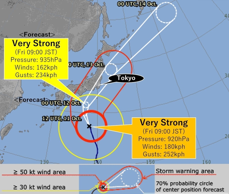
FORECAST TRACK OF HAGIBIS
The Japan Meteorological Agency, or JMA, says Hagibis has sustained winds of 180kph as of Friday and rated it as a very strong typhoon, which is the second highest category on Japan’s typhoon scale. JMA forecasts that it will likely make landfall in central Japan’s Tokai or Kanto regions by Saturday evening with the same status. The pressure upon landfall could be as low as 950hPa or even lower.
(気象庁によると、11日朝現在の19号の最大風速は50m/sで「非常に強い」勢力である。土曜日夜までに東海もしくは関東地方に中心気圧950hPaかそれ以下で上陸する可能性がある。)
HAGIBIS IS POTENTIAL RECORD TYPHOON
Japan is frequently battered by typhoons but most of them pound the western regions, such as Kyushu and Shikoku. Statistically, 77% of the typhoons hit the west, and 23% batter the rest of Japan.
The most intense storm, in terms of low pressure, for the country is Typhoon Nancy in 1961, which had 925hPa upon landfall in Shikoku.
For the Tokai region, the record is Typhoon Tess in 1953 with 946 hPa. That typhoon killed over 400 people and injured almost 2,500. For the Kanto region, which includes Tokyo, the record is 960hPa. If the forecast is right, Hagibis could be written in the history book as the most powerful storm to make landfall in the Tokyo area.
(日本は台風の常襲国であるが、統計では77%が西日本に上陸し、東日本に上陸するのは23%のみである。日本全土における史上最強の勢力の台風は上陸時の気圧が925hPaであった1961年18号、東海地方においては1953年13号の946hPa、さらに関東においては960hPaとなっている。もし950hPa以下で関東に上陸するとなれば史上最強の台風ということになる。)
POSSIBLE THREATS
[WINDS]
With the low pressure, we might experience unprecedented strong winds. Wind gusts could be up to 216kph, which is equivalent to the winds of a maximum EF 2 tornado. These winds can batter power poles, shift the foundations of frame houses, and lift up vehicles. Even light objects could be blown like missiles.
What concerns us the most is that there are still areas reeling from the previous typhoon Faxai. Gusts of over 200kph left the area without power for over a week and tore off numerous roofs from houses.
(風。記録的な台風となるために、前代未聞の強風が発生するおそれがある。最大瞬間風速60m/sの風が予想されているが、これはEF2の竜巻に相当する。この風のもとでは、電柱が倒れたり、家の基礎部分が動いたり、車が飛ばされる可能性がある。また軽いものもミサイルのように飛んでくるかもしれない。心配されるのは、台風15号の被災地である。15号は58m/sの強風を吹かせ、停電が一週間以上続き、多くの屋根が飛ばされる被害が出た。)
[RAIN]
Hagibis is not just a blustery storm, but also a huge storm. The area with winds in excess of 54kph is as large as 1,400km in diameter. The impact of the storm will last long, which in turn, will dump significant rainfall. JMA predicts the total rainfall into Saturday morning could be up to 1,000mm for Tokai and 750mm for Kanto. That would easily surpass a few months' worth of rainfall. The sewer system cannot keep up with rainfall at a rate of over 50mm and massive landslides with the collapse of beckrock could occur if the total rainfall is over 400mm.
(雨。19号はサイズも大きい。強風域の直径は1,400キロにも及ぶため、嵐が長時間続き、大雨となる。気象庁は48時間で東海地方で最大1,000ミリ、関東地方で750ミリの雨を予想している。数か月分の雨が降ることになる。時間降水量50ミリ以上では排水設備が追い付かないし、400ミリ以上の雨では深層崩壊と呼ばれる大規模な土砂崩れが起こる可能性がある。)
[ROUGH SEAS]
Waves are expected to hit 13m, which is as high as four-story buildings. What makes matters even worse is the timing. Saturday is close to a full moon, which means the water levels will be higher than normal. If the arrival of the typhoon coincides with the high tide, destructive coastal flooding will occur.
(大荒れの海。波は13mとビルの4階に匹敵する高さとなるかもしれない。さらに土曜日は満月で、満潮と重なれば、大規模な洪水が海岸線で起こる可能性が高い。)
PREPARE FOR THE WORST
We only have several hours before the peak of the storm. For those of you who live in Tokai and Kanto, today is the last chance to prepare for the typhoon. Electricity, water, phone and internet service might be cut off. Your house windows might be broken and your house may become flooded. Think about the worst case scenario and prepare for the unexpected.
(台風直撃までにもう時間がない。停電、断水、はたまた電話やインターネットがつながらなくなる恐れもある。東海や関東地方にお住まいの方は最悪の事態を想定して備えてほしい。)