Wrong Way NEPARTAK Disrupts Tokyo Olympics (台風8号)


On top of the unprecedented surge of Covid-19 cases, and along with the “some of the worst” heat torturing the athletes, a tropical storm is projected to make landfall in Japan on Tuesday. It would be the first tropical system to disrupt the Olympic games in history.
Development of Nepartak
Tropical Storm Nepartak formed over the Western Pacific on Friday evening, coincidentally when the opening ceremony of the Tokyo 2020 Olympics was taking place.
Thanks to the upper-level wind shear, Nepartak is not expected to intensify, but the projected path is threatening. Instead of taking the usual northeasterly track, the storm could move reversely aiming for Japan.
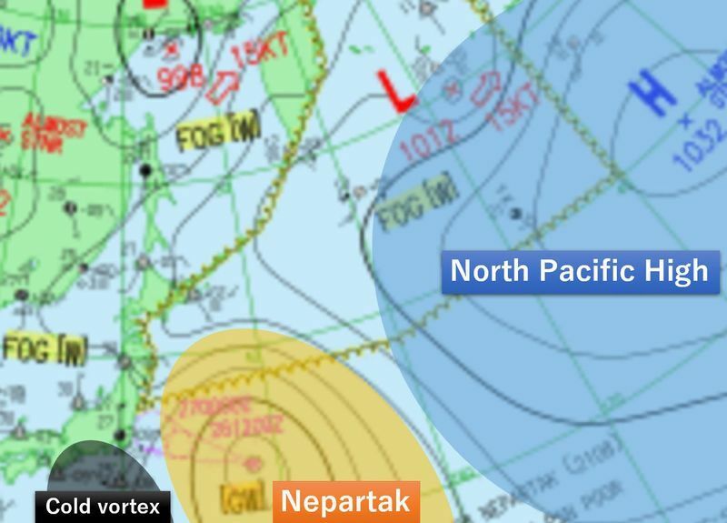
What makes the storm move wrong way?
The key ingredient of deciding the movement of typhoons is the position of the North Pacific High. Storms move along the edge of the high-pressure system, and the clock-wise circulation along the high pressure normally carries the storm eastward over the main islands of Japan.
However, currently, there is an upper-level low, called a cold vortex, south of Japan, shrinking the Pacific High. That puts Japan in the western rim of the high-pressure, which has southeasterly winds, allowing the storm to move northwest-ward. That makes Nepartak take such an extraordinary track.
Since reliable record keeping began in 1951, only one other tropical storm has taken this path toward the east coast of Japan. Lionrock in 2016 moved northwest-ward, making landfall on the Pacific side of Iwate Prefecture for the first time ever. Although Lionrock was a weak tropical storm by landfall, it caused extensive damage.
Expected stormy conditions
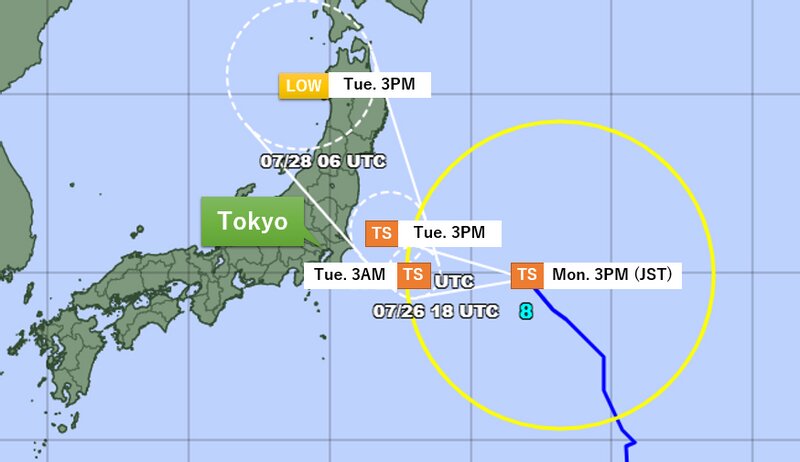
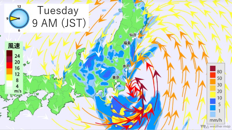
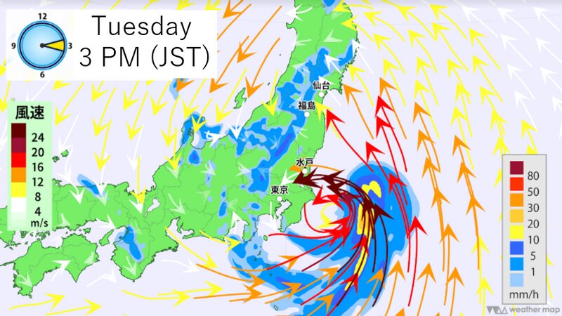
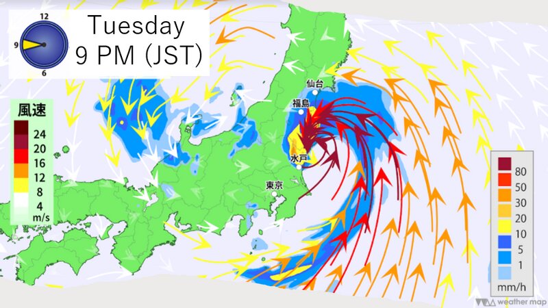
As of 3pm Monday, Nepartak is located about 1,500 km east of Tokyo with sustained winds of 72 kph. The Japan Meteorological Agency is forecasting it to maintain its intensity and make landfall on the Pacific coast between Ibaraki and Iwate prefectures sometime between Tuesday afternoon and evening. If the center of Nepartak reaches Ibaraki, Fukushima, or Miyagi prefectures, it would be the first tropical storm to do so in recorded history.
Because Napartak will cross Japan at a slow pace with the storm zone covering a wide area, heavy rain and strong winds could last for a long time. The expected rainfall amounts are up to 300mm in the Tohoku and Kanto regions from Monday noon to Wednesday noon. The expected wind gusts upon landfall could be as high as 108kph, and waves could be up to 6 meters along the Pacific coast.
Possible impacts on the Olympics
The Olympic organizers are starting to prepare for the arrival of the storm. At the competition sites, staff members were seen removing umbrellas and putting weights on the bulletin boards to prevent them from being blown away by strong winds.
As Nepartak will bring rough seas, the organizers have decided to postpone rowing events scheduled for Tuesday. Triathlons, beach volleyball, sailing, canoe, and surfing competitions could also be affected as well.
Unforgettable Olympics
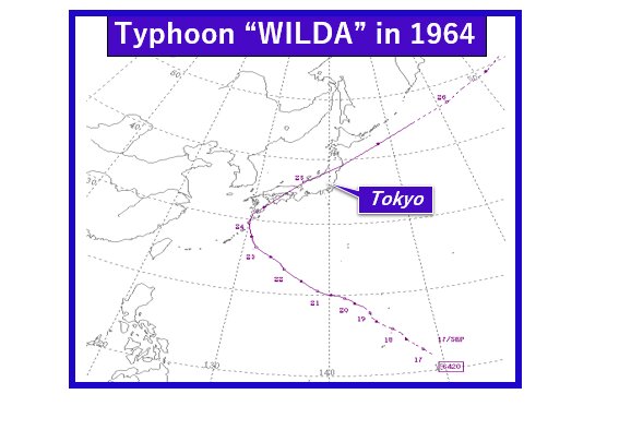
No other Olympic games in the past have been impacted by hurricanes, typhoons or tropical storms. During the last Tokyo Olympic Games held in 1964, strong winds from Typhoon Wilda damaged the athletes' accommodation, but it was a couple of weeks before the start of the Olympics. Tokyo 2020 could be unfortunately remembered as the first Olympics to be directly hit by a tropical storm in history.
There is a Japanese saying “taifu ikka(台風一過)” meaning clear weather after a typhoon. In spite of many challenges, as the storm passes, hopefully a calmer and brighter future lies ahead, just like a sunny day after the storm.
【意訳】
新型コロナウイルスの患者数の急増に加え、五輪選手が「史上最悪クラス」の高温に悩まされるなど、様々なニュースが付きまとっている東京五輪ですが、今後は「史上初の台風の直撃にあった五輪」となる可能性が高まっています。
五輪の開会式が行われていた23日夜、8号は発生しました。上空のウィンドシアの影響で強まる予想はありませんが、異例なコースにより被害が出る可能性があります。なぜ珍しい進路を取るのでしょうか。本来台風の進路を決める太平洋高気圧が、日本の南に位置する寒冷低気圧の影響で東に退き、南東風が台風を北西に動かすためです。1951年の統計開始以来、このように北西に動いて上陸した台風は2016年の10号しかありません。10号は強い台風ではありませんでしたが、観測史上初めて岩手県に上陸し大きな被害を出しました。
今回もし8号が茨城県、福島県、宮城県に上陸すれば、観測史上初めてとなります。
台風の接近を受け、看板が風に飛ばされないようにおもりをつけるなどの対策が取られています。またボート競技なども延期が決まりました。トライアスロンやカヌーといった競技にも影響が出る恐れがあります。
これまで世界で行われた五輪で台風やハリケーンに影響を受けたものはありませんでした。ほとんどがヨーロッパで行われていますし、アトランタやメキシコシティなどでもハリケーンが上陸していません。1964年の東京五輪では、台風20号が日本に上陸して選手村でも被害が出たようですが、それも開会式の2週間ほど前のことでした。今回の東京五輪が、史上初めて台風の影響を受けたオリンピックとなるかもしれません。
チャレンジ続きの東京五輪ですが、「台風一過」の諺のように、台風が去った後には明るい未来が待っていることを期待したいと思います。