【台風19号】Four Reasons Why Hagibis Will Be Dangerous


This year’s most powerful typhoon, Hagibis, is inching toward Japan.
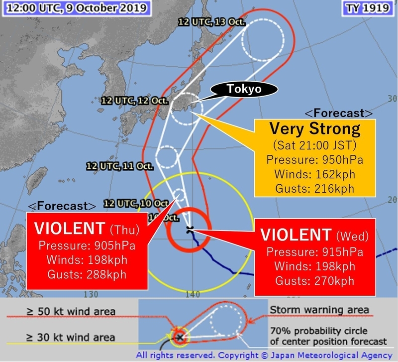
According to the Japan Meteorological Agency (JMA), Hagibis is categorized as a violent typhoon, which is the highest category on the Japan’s typhoon scale. (As of Thursday, its central pressure: 915hPa, sustained winds: 198kph).
JMA predicts Hagibis could weaken slightly as it churns over cooler waters and be over or near the Greater Tokyo area on Saturday evening as a very strong typhoon, the second highest category. The area will start to see waves and rain intensifying on Friday.
(今年最強台風19号が日本に接近している。気象庁によると、10日0時の19号の中心気圧は915hPa、最大風速は55m/sで「猛烈な」勢力となっている。今後やや弱まりながら北上し、12日夕方頃には「非常に強い」勢力で関東地方などに接近または上陸する見込み。11日から波や雨が強まる。)
Japan is a typhoon-ready nation
Statistically, Japan is the 3rd most typhoon-prone country in Asia with 11 typhoons approaching and 2 directly hitting the land each year. Japan is a typhoon-ready nation, but still Hagibis is threatening many people in Japan. JMA had an unusually early press conference to warn people, and TVs are giving typhoon coverage almost all day.
(日本は年間11個の台風が接近し、2個が上陸する、アジアで3番目の台風常襲国である。しかし19号に関する関心は高く、気象庁はいち早く会見を開いて注意を呼び掛けたり、テレビでは一日中台風の話題で持ちきりである。)
Four reasons why Hagibis is so dangerous
So, why is Typhoon Hagibis so special? Here are the four reasons why Hagibis could become a destructive storm:
(なぜそれほどまでに19号は恐れられているのか。それには4つの理由がある。)
1. Size
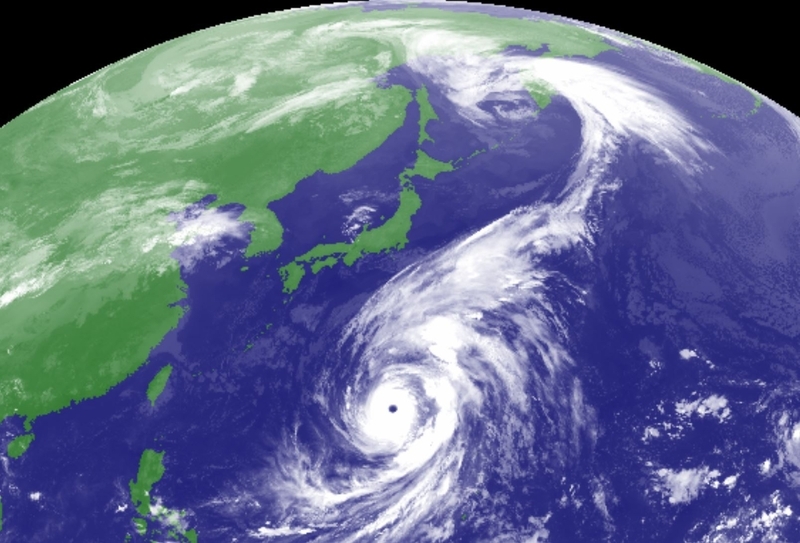
As shown on the satellite, Hagibis has a large area of clouds. The diameter of the windy area with speed of over 54 kph are 1,400 km, which is almost half the length of the Japanese archipelago. With the huge size, stormy conditions will start earlier, last longer, and affect wider areas.
(大きさ。衛星画像から分かるように、19号の雲は大きい。強風域は1,400キロにも及んでおり、これは日本のおよそ半分の長さに匹敵する。このため雨風は早くから強まり、長く続き、広範囲に及ぶ。)
2. Strength
Hagibis has a central pressure of 915hPa as of Thursday, making it one the most intense tropical systems on earth this year.
When it explosively developed near the Northern Mariana Islands, the central pressure plummeted from 992hPa to 915hPa within 24 hours. According to Digital Typhoon, this is the 9th-most rapid intensification in recorded history.
JMA forecasts the pressure could be 950hPa when it will be near Japan on Saturday. If Hagibis makes landfall in the Greater Tokyo area with that strength, it would be the strongest on record for the region.
(強さ。中心気圧は915hPaで、今年世界で発生した嵐のうち最大級の強さである。マリアナ諸島北部付近に位置していた時に、24時間で中心気圧が992hPaから915hPaと77hPaも下がった。デジタル台風によると、これは史上9番目の気圧降下である。気象庁は上陸までに950hPaまで下がると予想しているが、もしこの強さのままで関東地方を直撃すれば、史上最強の台風となる。)
3. Timing
What makes Hagibis even more scary is the timing of its landfall.
This coming weekend when Hagibis is projected to hit Japan, we will be in a full moon phase, meaning the water level at sea will be higher than normal. The combination of the high tide, giant waves and storm surges could bring a significant risk of coastal flooding.
(タイミング。19号は今週末に上陸すると予想されるが、その頃は満月の時期にあたり大潮と重なる。これに巨大波や高潮が加わることで、海岸線での洪水のリスクが高まる。)
4. Place
Hagibis could bring a second punch to the Greater Tokyo area in a month.
Typhoon Faxai battered the region as the strongest storm to do so on record early September, causing record-shattering 207 kph gusts in Chiba Prefecture. At least 3 people have been killed, hundreds of thousands of households remained without power for over a week and numerous homes lost roofs. There are still many houses with blue tarps on their roofs and people still in shelters.
(場所。先月はじめ台風15号が関東を直撃し、千葉市に58m/sという記録的暴風を吹かせた。少なくとも3人が死亡、数十万軒が数日間も停電となり、多くの家の屋根が飛ばされた。一か月たった今も、屋根にブルーシートが被せられている家や、避難をしている人々がいる。)
Impact on the Rugby World Cup
The storm is causing a headache for rugby fans.
Seven Rugby World Cup matches are scheduled to take place this coming weekend. Officials are considering cancellations of the matches or change of the venues for safety reasons. No Rugby World Cup matches in the past have been cancelled due to inclement weather.
(19号はラグビーファンにとっても悩みの種である。週末は7試合が予定されているが、中止か開催地変更もありうる。これまでに天候が理由でラグビーワールドカップが中止されたことはない。)
Stay updated
For those of you who are in the typhoon threat zone, keep up to date on the latest information on Hagibis.
Here are some useful links to get the typhoon updates:
(台風の被害が出ると想定される場所にいる方は、特に最新の気象情報を見て、安全を確保するよう心がけてください。以下に関連リンクを添付しています。)
●JMAWebsite for typhoon forecast
●NHK WORLD JAPAN's special page for typhoon
●JR EASTandWESTwebsite for traffic information
●TOURISM AGENCY's alert application
●JNTO's 24 hour visitor hotline
●RUBGY WORLD CUP's official site